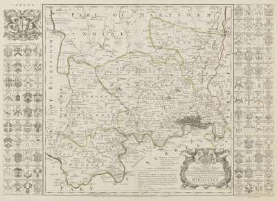
Richard William Seale was an engraver and cartographer based in Holborn. He engraved maps in the rococo style of Emanuel Bowen and Thomas Kitchin for the ‘Universal Magazine’ and also produced water charts and town plans in addition to larger maps and atlases. Cartographer and engraver Richard William Seale was based in Holborn. Examples of his work include a map for Thomas Gerard’s ‘Survey of Dorsetshire’ (1732) and a map of London of 1749, made in collaboration with John Rocque and engraved by the printmaker and draughtsman Isaac Basire. (Basire's eldest son, James, was apprenticed to Seale.)