An Accurate Map of Cambridgeshire
-
About the work
- Location
-
Country: Other
City: other locations abroad
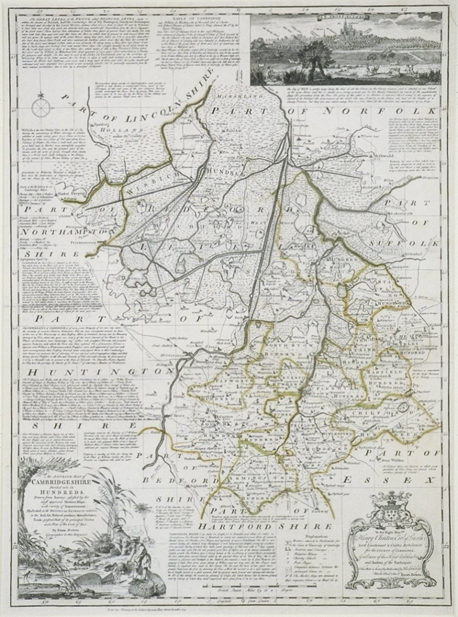
Emanuel Bowen’s coloured engraving depicts a detailed map of the county of Cambridgeshire. It is decorated with inset scenes of rural activities related to the area. In the lower left corner, a decorative cartouche shows a man eel-fishing; while the image at top right depicts a scene of duck shooting. The lower right cartouche explains that it is:
‘Drawn from Surveys, assisted by the most approved Modern Maps, with [a] Variety of Improvements. Illustrated with HISTORICAL EXTRACTS relative to the Soil, Air, Natural produce, Manufactures, Trade, present state of its principal Towns, and a View of the CITY of ELY, by Eman Bowen Geographer to HIS MAJESTY.’
The earliest maps, principally navigation charts, were made in Europe from the eleventh century. As maritime trade expanded in the Mediterranean and throughout Europe, the production of maps, their technical accuracy and the scientific instruments used to survey land became increasingly developed. Initially, a map’s cartouche contained only the title: however by the late 17th century it had developed into a grander artistic device and a minor art form in itself. Ornamentation and decorative flourishes were borrowed from the work of woodcutters and engravers.
-
About the artist
Emanuel Bowen was born in South Wales. He began his career as an apprentice to globe and instrument maker Charles Price. During his apprenticeship, he engraved maps for an ‘Atlas of the World’ (1717). In 1729 he produced his own ‘New and Accurate Map of South Wales’ and five topographical views of Welsh towns. He later drew 70 maps for his ‘Complete System of Geography’ (1744-47) and made a set of county maps for the ‘Large English Atlas’ (1760), in collaboration with map-maker Thomas Kitchen. Despite achieving the distinction of becoming geographer to George II in around 1747, Bowen’s obituary of 1767 stated that he died in ‘reduced circumstances’ - the result of ‘family extravagances’. His son, Thomas, was also an engraver and map-maker.
-
Explore
- Places
- England, Ely, Cambridgeshire
- Materials & Techniques
- engraving, coloured engraving
-
Details
- Title
- An Accurate Map of Cambridgeshire
- Date
- published 1753
- Medium
- Coloured engraving
- Acquisition
- Purchased from Francis Edwards, November 1949
- GAC number
- 989